
The Karst Firewall 5.0 project continues to advance with new tools for wildfire prevention and management in the Karst region, shared by Italy and Slovenia. Two recently published deliverables, D2.1.1 and D2.1.2, provide practical solutions to improve monitoring, preparedness and emergency response.
D2.1.1 – Digital Wildfire Risk Management System
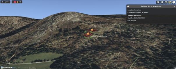
Deliverable D2.1.1 presents a digital system for seasonal wildfire mapping. It integrates Sentinel-2 satellite imagery, high-resolution drones, thermal and optical sensors, and autonomous aerial laser scanning.
The system provides data four times per year, covering key seasons. It feeds into a digital platform featuring:
- Interactive risk dashboards
- Preventive planning modules
- Real-time weather data integration
- 3D visualisation of wildfire areas
This tool supports local authorities in making timely, data-driven decisions.

D2.1.2 – Integrated Historical Dataset for Wildfire Prevention
This deliverable showcases a key outcome of cross-border collaboration. Italian and Slovenian institutions have created the first harmonised dataset for wildfire prevention in the Karst ecosystem.
The dataset includes:
- 5,229,216 historical meteorological records
- 3,958 documented wildfire events
- 50+ high-resolution geospatial layers
- Temporal coverage: 1991–2024
Far from being static, the dataset powers AI-driven predictive models with 97% accuracy in wildfire risk forecasting.
The integration required overcoming technical differences in data formats, coordinates, and classification methods. Now fully compliant with INSPIRE standards, the dataset serves:
- Scientific research
- Land-use and risk planning
- Early warning systems
Both deliverables are available on the Karst Firewall 5.0 digital platform. They offer a replicable model for other cross-border regions and a valuable contribution to climate risk mitigation in sensitive ecosystems.